
|
Black
Rapids
The
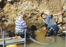
photo below is of my very good friend Helio Zwi and myself. We were
working on 'One Mile Creek, which crosses the Richardson Highway at Black
Rapids. We set up my 21/2" dredge on legs and worked a spot very
close to a cutbank that was about 12' high....it was all water washed
gravel and sure looked like a good spot......Wrong! we worked for about
3 hours and came up with just a few specks of gold in the cleanup. It
was a very enjoyable time......prospecting always is!
The
Richardson highway, about 40 minutes south of The mountains to the east of the river, rise sharply out of the flood plain, giving birth to numerous small creeks. These creeks, because of their proximity to the mountains, are very short. They have cut deep crevasses in the country rock of the mountains. These are ‘glacial’ creeks, fed by the formation of ice coming from ground water. As the season progresses, the ice in the higher elevations builds up. The water then flows over the ice causing a buildup called ‘overflow’. The result is small glaciers that melt in the summer sun. Because of this characteristic, they are very clear running, very cold, and the water volume fluctuates greatly between day and night. These creeks are not to be confused with the glacial streams coming from true glaciers. True glaciers are composed of ice that may be many hundreds of years old and very dense in it’s makeup. They surge back and forth within the confines of their respective valleys, and exert a tremendous amount of pressure on the rock they slide on. This characteristic of glaciers makes for very gray, cloudy water as the resulting pulverized rock remains suspended in the receiving stream. Incidentally, this stream that is formed by the melting of the glacier is more than a mere trickle, it can be the size of a river. And, by the time it reaches the Tanana River, it looks like a river of gray mud But....I digress!
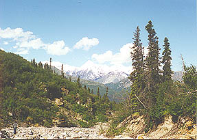
This
area makes for a very enjoyable weekend outing. It is set amid the
scenic splendor of wild Alaska at it’s best. Even if you don’t find
anything here, you will remember the experience for the rest of your
life because of the beauty that surrounds you on all sides. If
you are fortunate, (as we were) you may even be able to see Dall Sheep
on the surrounding mountains. We even had a cow moose with her two month
old calf approach us. Oh, just one other detail, there are no services
of any kind here for at least 40 miles, so bring anything that you may
need with you. |
 The
creeks that run into the Tanana at this point have produced some
interesting results for weekend prospectors over the years. Because of
their proximity to the highway, they are very accessible. It is a
perfect place for prospectors to sluice, highbank or use a small suction
dredge. Although not a large producer of gold, these creeks have
never-the-less been good to a handful of persistent prospectors. I will
not go into all the details of the discoveries made over the years here.
Ron Wendt, in his book, "How to Prospect for Gold in Alaska Without
Getting Shot", does a very thorough job of detailing these
discoveries. I can recommend his work highly, he has written many
excellent books on the subject of prospecting in Alaska.
The
creeks that run into the Tanana at this point have produced some
interesting results for weekend prospectors over the years. Because of
their proximity to the highway, they are very accessible. It is a
perfect place for prospectors to sluice, highbank or use a small suction
dredge. Although not a large producer of gold, these creeks have
never-the-less been good to a handful of persistent prospectors. I will
not go into all the details of the discoveries made over the years here.
Ron Wendt, in his book, "How to Prospect for Gold in Alaska Without
Getting Shot", does a very thorough job of detailing these
discoveries. I can recommend his work highly, he has written many
excellent books on the subject of prospecting in Alaska.