|
Can you unlock the mystery?
Want to talk to modern day prospectors? Would you like a place where you can ask questions about mining in Alaska, or just see what a great bunch of folks Alaskan miners are? Come and join the fun on the Alaska Gold Forum, we love visitors.
Click Here
The photo below is of my very good
friend Helio Zwi and myself. We were working on 'One Mile Creek, which crosses the
Richardson Highway at Black Rapids. We set up my The mountains to the east of the river,
rise sharply out of the flood plain, giving birth to numerous small creeks. These creeks,
because of their proximity to the mountains, are very short. They have cut deep crevasses in the
country rock of the mountains. These are ‘glacial’ creeks, fed by the formation
of ice coming from ground water. As the
An Expensive Lesson Published in Gold and Treasure Hunter Magazine Aug.1998 It was summer in Alaska, 1985. My partner Dan and I were headed north from our homes in Fairbanks on a four day prospecting trip to the Koyukuk River. The Koyukuk is located 200 miles north of Fairbanks, and 50 miles north of the Arctic Circle. This river is well known as a gold producer and records show that it has consistently produced some of the largest and most beautiful nuggets in the state. As we turned onto the Dalton highway the sun was
just starting to dip below the horizon to the north, it was midnight, this is Alaska the
land of the midnight sun. We had begun this trip at this time of night because we wanted
to arrive at the river between Alaska is a land of extremes and the weather is no exception, by the time we reached the mighty Yukon River we could see a dark line of clouds stretching from east to west as far as the eye could see. Just north of the Yukon River we ran into the rain, it was really coming down. This was not good, as most prospectors know, swollen rivers are not the best places to try to prospect. Immediately the road turned into a slick gumbo and as we traveled, the spray from passing tractor-trailers, whose road this was, covered our truck and the canoe on top with a thick layer of gray mud. 50 miles north of the Yukon we pulled over into a gravel pit, got out the Coleman stove and cooked some of the food we had brought. We couldn’t really call it dinner or breakfast, it was three o’clock in the morning, it was just food. While stretching his legs and sipping his coffee, Dan called me over to see a very large set of Grizzly tracks in the wet mud…..Well, time to leave. Our story really had it’s beginning some six months before in the heart of the Alaskan winter. It was December, the time when all a prospector has to do is wait for next summer and reflect on summers past. We had seen an ad in the paper offering to sell two claims. Having nothing better to do, we made an appointment to meet the owner the next night. It turned out that he had two recorded claims on the Koyukuk River that he wanted to sell, he needed money for Christmas and was not working. He showed us four 5oz. vials of course flakes that he said came from his claims. He had supposedly got them with a two and one half inch dredge the preceding summer. Needless to say, we were excited, gold was almost $800.00 per oz. and what he held in his hand was worth $16,000.00!!! He was desperately trying to hold on to his gold, but he needed money. He wanted $8,000.00 for the two twenty acre claims and he would sign a quit claim deed. For me, that was a lot of money, and no guarantee that the gold he showed us was from that claim. We could not test the ground before we bought it because it was December and that ground would be a hard as concrete. Fortunately a geologist from the Dept. of Natural Resources had visited his claims that last summer and could verify that what he said was true. He had taken 20 oz. of course flakes in about thirty hours of work. We bought the claims and waited impatiently for summer. Leaving the bear tracks in the mud, we again
headed north, full of anticipation, and doubt, it was still pouring cats and dogs. What
would the river be like? Would we be The winter before, while waiting for summer to
come, we had done some research on the claims and the area surrounding them. We found that
there were two large blocks of claims adjoining ours on the west or, left limit of the
river. There was also a large cat mining operation opposite our claims and just downstream
on the right limit. This information not only served to confirm that we had made a good
purchase, but had the exasperating effect of immediately adding to the length of the
winter.
We noted that on our right there was a bench
about twenty feet high, this bench looked like it had been formed by the erosion of the
ridge that we were approaching. It also looked very much like the small creek had, over
time, washed through the bench at this At this point we were forced to seek the high ground, this would not be the best place for prospecting but it was all we had. It would seem that we had made a mistake in not bringing our 2 ½" dredge, this would be the only way to prospect this piece of ground. Climbing to the top of our bench we began to take some samples. As is the case in most of the interior of Alaska, the ground here was covered in a thick blanket of moss and lichen. Lichen is the staple food of the Caribou that roam these hills. Rolling back the thick carpet of moss with our shovels, we found gravel, not rounded and water washed, but sharp angular gravel. Dan said that he didn’t think that this looked too promising and I had to agree. We took a shovel full and put it in the pan and climbed back down the bench to the creek. In just a couple of minutes we had the pan of gravel reduced to the point that we could see the bottom of the pan when we shook it. You can imagine our surprise as we carefully washed the remaining contents of the pan and saw yellow gleaming up at us from the green bottom of the pan. GOLD! And from the first shovel of gravel. There were 12 colors in the first pan, and each successive pan yielded anywhere from 10-20 colors. This was what we had waited for all winter for. We prospected for the rest of the day in the pouring rain, then turned in for the night. We would have to leave in the morning, the river was getting dangerously high. The next morning the river looked ugly, it had
stopped raining but you could see the river was still rising. It was all our little motor
could do, with Dan paddling as well, to The expensive part of this story happened about two weeks later. I had a business in Fairbanks that demanded a lot of my time. A problem developed with my bank over a very large business expansion loan I had. They made some illegal moves and I sued, and from then on things got hectic. To make a long story short, I never could get back there to do the assessment work to keep the claim. Then the inevitable happened, the guy I had bought the claims from re-filed on them. He has held them for the past eleven years. But this year I got a break, I was checking the claim records and found that he had dropped them. The Federal Government instituted a $100.00 per year fee for each claim held. This has caused a lot of miners who were just holding claims to drop them, because of the expense of holding a large number of claims. Needless to say, I will be heading north with my new partner, Jesse, this spring to re-stake these claims. It has been a lesson well learned. The author is a member of
Copyright 2004
|


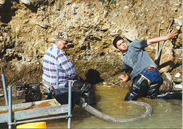 21/2" dredge on legs and worked a
spot very close to a cut-bank that was about 12' high....it was all water washed
gravel and sure looked
like a good spot......Wrong! we worked for about 3 hours and came up with just a few
specks of gold in the cleanup. It was a very enjoyable time......prospecting always is!
21/2" dredge on legs and worked a
spot very close to a cut-bank that was about 12' high....it was all water washed
gravel and sure looked
like a good spot......Wrong! we worked for about 3 hours and came up with just a few
specks of gold in the cleanup. It was a very enjoyable time......prospecting always is!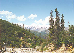 season progresses, the ice in the higher
elevations builds up. The water then flows over the ice causing a buildup called
‘overflow’. The result is small glaciers that melt in the summer sun. Because if
this characteristic, they are very clear running, very cold, and the water volume
fluctuates greatly between day and night. These creeks are not to be confused with the
glacial streams coming from true glaciers. True glaciers are composed of ice that may be
many hundreds of years old and very dense in it’s makeup. They surge back and forth
within the confines of their respective valleys, and exert a tremendous amount of pressure
on the rock they slide on. This characteristic of glaciers makes for very gray, cloudy
water as the resulting pulverized rock remains suspended in the receiving stream.
Incidentally, this stream that is formed by the melting of the glacier is more than a mere
trickle, it
can be the size of a river. And, by the time it reaches the Tanana River, it looks like a
river of gray mud.
season progresses, the ice in the higher
elevations builds up. The water then flows over the ice causing a buildup called
‘overflow’. The result is small glaciers that melt in the summer sun. Because if
this characteristic, they are very clear running, very cold, and the water volume
fluctuates greatly between day and night. These creeks are not to be confused with the
glacial streams coming from true glaciers. True glaciers are composed of ice that may be
many hundreds of years old and very dense in it’s makeup. They surge back and forth
within the confines of their respective valleys, and exert a tremendous amount of pressure
on the rock they slide on. This characteristic of glaciers makes for very gray, cloudy
water as the resulting pulverized rock remains suspended in the receiving stream.
Incidentally, this stream that is formed by the melting of the glacier is more than a mere
trickle, it
can be the size of a river. And, by the time it reaches the Tanana River, it looks like a
river of gray mud. 6-8:00am. The Dalton Highway is a gravel road that was built to
accommodate the Prudhoe Bay oil fields 450 miles to the north of Fairbanks. There are no
services on this road except two truck stops, one on the north bank of the Yukon River and
one in a place called Coldfoot 200 miles to the north of the Yukon River. If you get in
trouble you are on your own.
6-8:00am. The Dalton Highway is a gravel road that was built to
accommodate the Prudhoe Bay oil fields 450 miles to the north of Fairbanks. There are no
services on this road except two truck stops, one on the north bank of the Yukon River and
one in a place called Coldfoot 200 miles to the north of the Yukon River. If you get in
trouble you are on your own. able to properly prospect the claims we had bought?
We had never been to the Koyukuk River before, so we didn’t know what to expect, was
it large, was it small, would we be able to navigate it? We did know that our claims were
only three miles downstream from where the road crossed the river, so how bad could it be?
able to properly prospect the claims we had bought?
We had never been to the Koyukuk River before, so we didn’t know what to expect, was
it large, was it small, would we be able to navigate it? We did know that our claims were
only three miles downstream from where the road crossed the river, so how bad could it be? We had set up camp on a small rise of land that
would keep the tent out of any standing water….we hoped. We began by tracing the creek from the river
until it began to rise up to a ridge that rose out of the valley floor. The creek
traversed a small swampy area that held the water very well. Nowhere was the creek over
three feet wide and went from ankle deep to mid thigh in places. These swampy areas are
called "muskeg" in Alaska, they consist of mounds of grass with water in
between. The mounds of grass can be as much as two feet high and you cannot walk on them,
they tip over and spill you into the water. Attempting to walk between them is frustrating
because if the grass mound is two feet high, and the water between a foot deep, you have
to lift your leg three feet at each step.
We had set up camp on a small rise of land that
would keep the tent out of any standing water….we hoped. We began by tracing the creek from the river
until it began to rise up to a ridge that rose out of the valley floor. The creek
traversed a small swampy area that held the water very well. Nowhere was the creek over
three feet wide and went from ankle deep to mid thigh in places. These swampy areas are
called "muskeg" in Alaska, they consist of mounds of grass with water in
between. The mounds of grass can be as much as two feet high and you cannot walk on them,
they tip over and spill you into the water. Attempting to walk between them is frustrating
because if the grass mound is two feet high, and the water between a foot deep, you have
to lift your leg three feet at each step. point. We continued up the creek until it became
very steep and boulder strewn. At this point it was not possible to do any digging without
a lot of boulder moving to get to the gravel below. We opted to return the way we had come
and concentrate our efforts lower down. Try as we might, we could not find a piece of
ground that was not covered with standing water. It was impossible to dig and test the
gravel in this swampy area.
point. We continued up the creek until it became
very steep and boulder strewn. At this point it was not possible to do any digging without
a lot of boulder moving to get to the gravel below. We opted to return the way we had come
and concentrate our efforts lower down. Try as we might, we could not find a piece of
ground that was not covered with standing water. It was impossible to dig and test the
gravel in this swampy area. make any headway
against the current. It took about two hours
to go the three miles, but we made it back to the truck safely. We were happy prospectors,
talking excitedly about our discovery all the way home, and making plans to come back.
make any headway
against the current. It took about two hours
to go the three miles, but we made it back to the truck safely. We were happy prospectors,
talking excitedly about our discovery all the way home, and making plans to come back.